

MGC Site Intelligence
MGC Site Intelligence Tools
Tools and methods that strengthen every stage of site investigation, from desktop study to final deliverable.
Good site decisions start with knowing what the data already says. At MGC we build our own geoscience tools so every project gets the same careful, repeatable process. With them we pull survey data, public records and published research into one consistent picture of your site, and we check each result before it reaches you. Our clients get clearer answers sooner, investigations aimed where the uncertainty is highest, and deliverables that open in the software their teams already use.
The examples below show what we deliver today.
3D Ground Models
Our custom tool allows for quick, precise ground model construction from a variety of raster and vector data sources to support your project needs. MGC's tool generates cross-sections from the same ground model surfaces and integrates subsurface and point source data directly in a GIS environment. You receive the model, the sections and an interactive 3D viewer that opens in any web browser.
Below is an example of the MGC 3D Ground Model for Starbase Louisiana, a pre-investigation model built entirely from public data. Feel free to tour the interactive tool below!
Metocean Screening Services
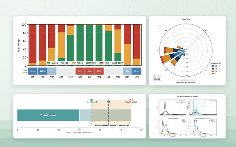
MGC's GIS based tool screens the exact project location and establishes a Metocean assessment based on years of satellite data (ERA5 / Copernicus), or buoy records where they exist. The result shows what the site will actually allow: how often you can work, in which months, and how much weather contingency to build into the schedule.
What you get:
-
Site screening report: a quick look at one or more candidate sites or routes, showing workable months and the main weather risks
-
Metocean report: the full analysis for your operation, with operability by month against your vessel limits, monthly downtime at P10, P50 and P90, and wind, wave and current roses
-
Wave spectrum analysis: separates long-period swell from local wind-sea, which often decides ROV, lifting and survey operations
-
Forecasts: site-specific forecasts during mobilization and operations, checked against the same limits used in planning
Coastline and Satellite Analysis
Utilize advanced satellite data to monitor coastal changes effectively. Our analysis provides crucial insights for informed decision-making in coastal management. This is a cost-effective way to get context for nearshore projects, landfalls and permitting, before or alongside field surveys.